Writer's Block | November 29th, 2017

John Bluemle’s new book, “North Dakota’s Geologic Legacy” (actually published in 2016 and now in its second printing), is the culmination of a career of more than 40 years he spent with the North Dakota Geological Survey, researching all facets of North Dakota’s geology, and carrying the title of State Geologist.
It’s his fourth in a series of books designed, as he says, “for physical and armchair travelers.” His earlier work, “The Face of North Dakota,” comprised three editions, as he constantly updated it to keep up with demand and the changes we humans have brought to our state’s landscape.
This new work, from the North Dakota State University Press, should be required reading in our schools, and, for those of us past school age, it can serve as a marvelous guide as we take advantage of the outdoor recreational opportunities our state provides.
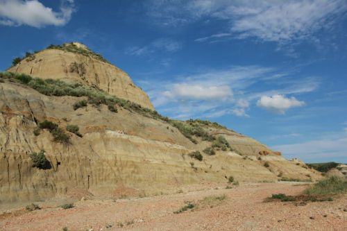
For North Dakotans who love the Bad Lands, as I do, Bluemle provides a rich and easy-to-understand explanation of what we are seeing and why we are seeing it as we drive, hike or canoe deep into the canyons carved by eons of wind and water on fragile soil.
He devotes a lot of ink to the Bad Lands, rightfully so, since it is our most interesting geologic area, but if you have ever been curious about sand hills, eskers, anamooses, geologic beaches, buttes, potholes, cannonballs, flint, kames, veblens, or natural terraces, and the forces that formed them, this book is for you.
Or even if you’re not overly curious about those landforms, it’s fun to look out the car window as you drive through our state and know what it is you’re looking at, and how it got there.
First, a bit about the author, John P. Bluemle. He came to North Dakota from Montana, right out of college, geology degree in hand, and went to work as a geologist for the North Dakota Geological Survey. He never left. Instead, he spent more than 40 years traveling our state, studying every major landscape system in the state.
In his foreword to the book, geology professor Eric Brevik writes “There probably isn’t anyone alive today who knows more about North Dakota’s geology or who has reached out to the public to expand general knowledge of the state’s geology.”
In this book, Brevik writes, Bluemle takes the reader on a wonderful journey through landscapes dominated by deposits from glaciers, ancient lakes, running water, and erosion. And, Brevik points out, the book is written for non-scientists.
Geology is important. It helped determine where people settled and where people live today. Our vast energy resources—not just coal, gas and oil, but wind, solar, geothermal and hydroelectric energy as well, are a direct result of our geological heritage. And Bluemle discusses each of these in one of the book’s most interesting and timely chapters.
How, and when was the Bakken formed? How does horizontal drilling work? What’s the future of solar energy here? Did you know that North Dakota’s long summer days and dry climate provide more sunlight than any other state along the Canadian border? Did you also know that lignite coal could be gasified 2,000 feet underground, producing vast quantities of synthetic natural gas without disturbing the landscape and without any air pollution?
The book is a treasure trove of information and caution about the use of our energy resources. I hope the owners of every energy company doing business here read it.
But mostly, for me at least, the book answers the questions I have about what I am seeing as I drive through North Dakota, or walk through my favorite hiking and hunting places.
And since I spend much of my time in the Bad Lands, I love that he gives that area of the state special attention. In his summary of that chapter, he writes “The geology is only part of the badlands story. The weather and climate, vegetation, animals, birds, insects, sounds and aromas—all of these, along with the human history and the ranching heritage, work together to complete the story of the badlands.”
(Note: He and I have different terminological treatments of the area called “the Bad Lands” or “the badlands.”)
“I have hiked and camped in the badlands many times,” he writes. “Evening summer showers accentuate the colors, and the clinker beds assume intense shades of red and orange. The fresh, pungent aroma of wet sage and cedar enhance the experience. At night, the stark, intricately eroded pinnacles can seem unreal. In the moonlight, or in a night lightning storm, it is easy to imagine the strange shapes as ruins of a magical city rather than structures of mere sand and clay. Blend in the sound of coyotes conversing, and the badlands environment is complete.”
Who says scientists can’t write?
The book takes us across the state from west to east, and as we travel we learned that the tops of our thousands of buttes, and indeed, even the Killdeer Mountains, were once the bottom of giant lakes. The hard caprock preserved them while all around them, the land eroded away as the lakes receded, leaving what once were lake bottoms as now the highest points in our state.
Midway through the ice age, a glacier blocked the Missouri River, likely not far from where the Garrison Dam is today, Bluemle tells us, forming “the original Lake Sakakawea: an early ice-dammed lake that predated the Corps of Engineers version of Lake Sakakawea by thousands of years.”
The Missouri Escarpment, the near-absence of rivers and streams flowing into the Missouri from the east, The Turtle Mountains, the terraces of the Sheyenne and James Rivers, and the flat, flat Red River Valley, once the bed of a glacial lake, all have geologic origins. Their stories are fascinating. As are the stories of things no longer here, like Glacial Lakes Souris, McKenzie, Dakota, Minnewaukan, and Cando.
All those things and more, Bluemle shares in the pages of a 375-page book, beautifully printed on heavy gloss paper, and, making it more enjoyable are the abundance of high-quality color photos (taken by the author), charts, graphs and illustrations, and Bluemle’s translation of the vernacular of geology into layman’s terms.
Yes, John Bluemle probably had the best job in the state. He got paid to drive around and explore and examine our landscape. And he has used it to share with us a wealth of easy-to-read information no one else has ever compiled.
His book is available at the North Dakota Heritage Center, most North Dakota bookstores, and online. Because of its high-quality printing, it’s a bit pricy at $40, but worth every penny, especially when we read the words of a crusty old geologist as he sends us on our way at the book’s conclusion with these words:
“We ask much of our land—and the land, in turn, challenges us. We farm the fields, drink the water, build our homes and businesses, pump the oil and gas, mine the coal and sand and gravel, bury the wastes and play in the parks. Our land provides the basis for all we are. City people depend on it just as much as those who live in rural areas. Each of us needs clean water, fresh air, open space and the chance to experience the natural marvels surrounding us.
“As we look at today’s North Dakota, we strive to appreciate yesterday and anticipate tomorrow. Both our past and our future are rooted in our land, and in its ability to work for us and with us. If we understand the geological history and natural processes that have shaped the landscape, we can better apply that knowledge to conserve and renew it.
“As we constantly mold and remodel the land to suit our needs, it is important that we adapt to the changes we impose upon it. However we choose to treat our land—gently and with respect, or harshly and callously—we are shaping the legacy we leave our children.”
Read this book.
December 18th 2025
June 19th 2025
June 19th 2025
June 19th 2025
April 22nd 2025
__293px-wide.png)

_(1)_(1)_(1)_(1)_(1)__293px-wide.jpg)
_(1)__293px-wide.jpg)

